


The Nho Que River boat ride offers stunning turquoise waters, but confusing piers and steep access roads can easily ruin your itinerary. Don’t let poor planning waste your daylight! This guide reveals exact ticket prices (100k-150k VND), wharf logistics (Ta Lang vs. Xin Cai), and safety tips to conquer this canyon smoothly. 💡

The Nho Que River boat ride is a highly photographed hour of the entire Ha Giang Loop, and also the stretch many riders reach with the least real planning behind it. Everyone who searches Nho Que River Vietnam boat trip the night before crossing Ma Pi Leng sees the same turquoise photos, but rarely arrives already knowing which pier to use, what the ticket actually costs, or whether the access road down to the water is something a loaded motorbike should attempt at all. Arriving at the wrong wharf, or riding an unfamiliar switchback with no idea how steep it gets, wastes riding time and adds real risk on a day that is usually already tight. I am Vani, founder of Truly Voyage, and this guide names the exact piers, the current price, and the road difficulty in advance, so the boat ride is something you plan into your loop rather than improvise on the spot. 🚤
Table of Contents
ToggleWhat Is the Nho Que River Boat Ride Really Like?
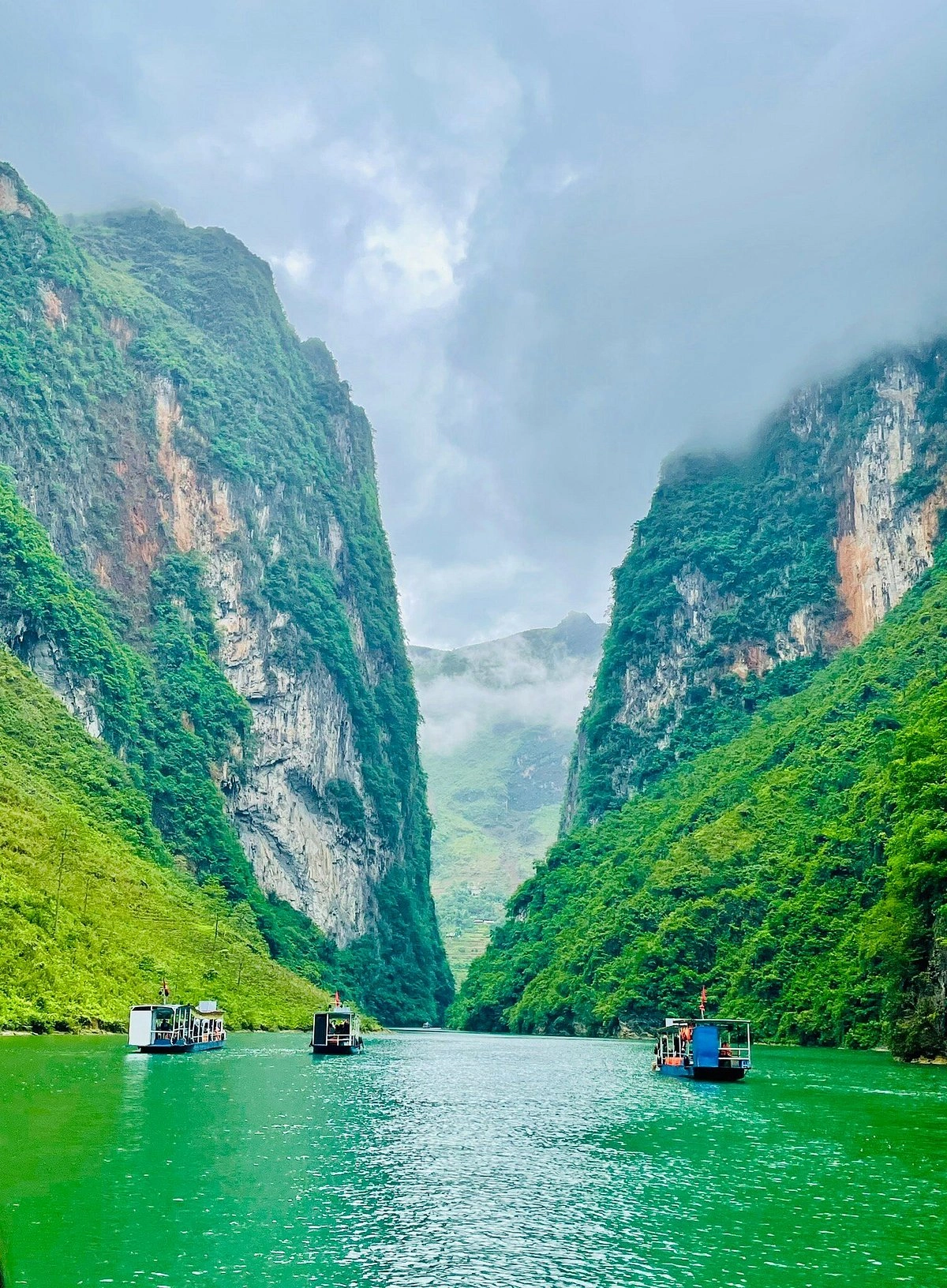
The boat ride carries you into Tu San Canyon, generally cited as one of the deepest canyons in Vietnam and Southeast Asia, drifting slowly beneath the sheer cliffs of Ma Pi Leng Pass for roughly 60 to 90 minutes round trip. ⛰️
Tu San Canyon runs about 800 meters deep and 1.7 kilometers long, with cliff walls rising at a 70 to 90 degree slope directly from the water, a scale that photographs consistently undersell until you are actually sitting in a small boat looking straight up (Source: VietnamPlus). Boats move at a deliberate, unhurried pace, and most operators pause the engine entirely at the narrowest point of the canyon, giving passengers several minutes of near-silence with only the cliffs, the water, and the occasional bird for company before turning back toward the pier. Life jackets are standard equipment on the larger motorboats operating from both piers, and the water itself stays calm enough for the entire route that this reads as a scenic float rather than anything resembling rapids. 🌊
How Far Is the Nho Que River From Hanoi?
Plan on roughly 410 to 430 kilometers for the full Nho Que River from Hanoi distance, split into a 300-kilometer overnight bus leg to Ha Giang city followed by another 110 to 130 kilometers of mountain road on to Meo Vac.
Most travelers cover the first leg on a sleeper bus, arriving in Ha Giang city in the early morning with a full riding day still ahead of them, a route our Ha Giang Loop guide covers in full, including bus operators and self-drive alternatives. 🚌 From Ha Giang city, the direct road to Meo Vac covers that final 110 to 130 kilometers in around 4 to 5 hours of actual riding time, though nearly every rider instead spreads this leg across two or three days on the standard loop, stopping through Yen Minh and Dong Van first rather than riding straight to Meo Vac, which is exactly why the boat ride tends to land on day 3 of a typical itinerary rather than day 1.
Vani Tip: book your Hanoi to Ha Giang sleeper bus for a departure that lands you in Ha Giang city by 6am, not later. I have watched guests lose almost half a riding day to a bus that arrived at 9am instead, time that is genuinely difficult to make up again once you are three days into a loop with a boat ride and a mountain pass still ahead of you. ⏰
Which Wharf Should You Use, Ta Lang or Xin Cai?
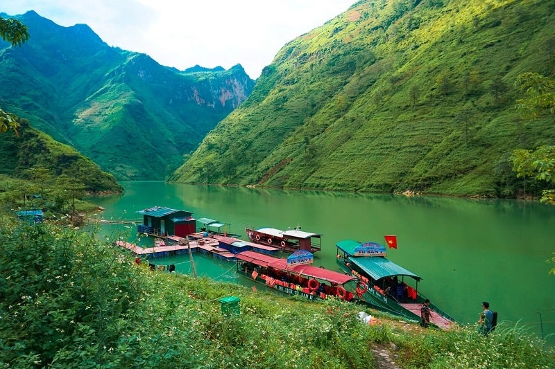
Ta Lang Wharf sits closer to Dong Van and Xin Cai Wharf sits closer to Meo Vac, so the right choice for most riders inside Nho Que River Ha Giang planning comes down to a single question, which town are you sleeping in that night.
Ta Lang Wharf sits in Ta Lang village, Pai Lung commune, roughly 4 kilometers from Dong Van town by road, making it an obvious choice for anyone overnighting in Dong Van before or after the crossing (Source: Vinpearl). Xin Cai Wharf sits in Xin Cai commune, Meo Vac district, reached from the eastern end of Ma Pi Leng Pass, roughly 5 kilometers of road followed by about 2 kilometers on foot down to the mooring point, making it a natural pick for anyone based in Meo Vac instead. Both piers put you on the same canyon, the same cliffs, and effectively the same photographs, so the decision genuinely comes down to logistics rather than which view is visually stronger.
| Ta Lang Wharf | Xin Cai Wharf | |
|---|---|---|
| Nearest town | Dong Van, about 4km | Meo Vac, via the eastern pass end |
| Access from parking | Steep road with dangerous turns down to Trang Huong bridge, then a short local shuttle | About 5km of road, then roughly 2km on foot to the mooring point |
| Best for riders staying in | Dong Van the night before or after | Meo Vac the night before or after |
| Canyon view from the boat | Same Tu San Canyon stretch | Same Tu San Canyon stretch |
Table 1: Comparison of access and location details between Ta Lang and Xin Cai wharfs.
Vani Tip: choose Xin Cai Wharf over Ta Lang if you are already staying in Meo Vac that night. It saves you doubling back toward Dong Van, and the boat covers the same dramatic stretch of canyon either way, so you lose nothing on the view by picking the closer option.
How Much Does a Nho Que River Boat Cost in 2026?
Expect to pay roughly 100,000 to 150,000 VND per person for a standard boat ride as a 2026 reference figure, confirmed directly at the pier since prices do shift with season and operator. 💵
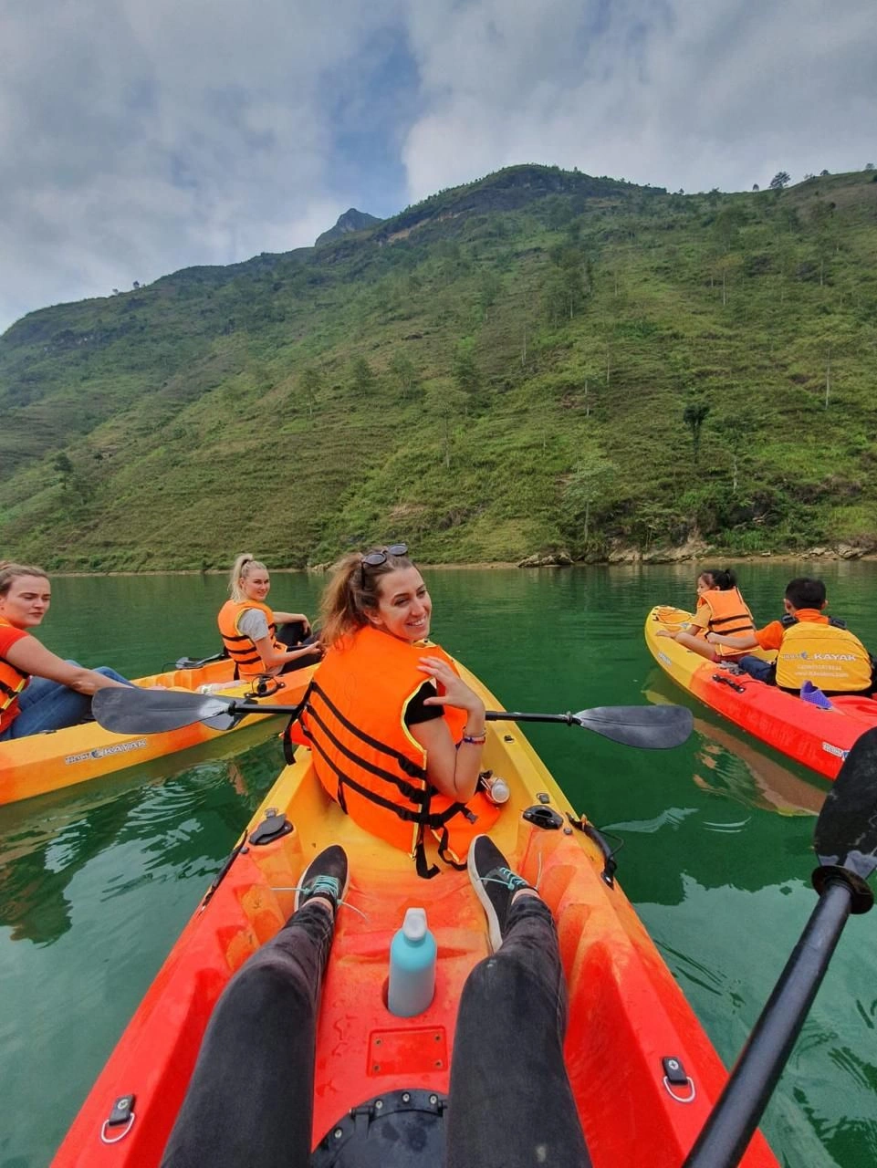
Pricing varies slightly by boat type and by which pier you launch from. A shared motorboat typically runs 100,000 to 150,000 VND per person, a self-rowing boat sits in the same 100,000 to 150,000 VND range, and kayaks start lower, from around 50,000 VND per person, for travelers who want a more active version of the same route. At the boarding facility on the Meo Vac side of the canyon, one operator quotes a flat 120,000 VND for adults and 60,000 VND for children under 1.2 meters tall, a useful real-world reference point even though rates at other piers vary (Source: Vietnam Coracle).
Most piers still operate on a cash-only basis with no advance online booking, so bring small denomination Vietnamese dong notes rather than assuming a card machine or a bank transfer will work at the water (Source: Local Vietnam). Travelers who would rather not negotiate pricing on the spot can arrange a pre-booked Nho Que River tour through an operator like Truly Voyage instead, with the seat and price locked in before you ever reach the water.
Ready to Explore the Ha Giang Loop Stress-Free?
Join Truly Voyage for an unforgettable adventure. We handle the logistics, you enjoy the ride!
How Do You Fit a Nho Que River Tour Into Your Loop Itinerary?
Slot the Nho Que River tour into day 3 of a standard 4-day loop, the same short riding day that already covers Ma Pi Leng Pass between Dong Van and Meo Vac, rather than treating it as a separate detour on its own day.
Riders researching Nho Que River Ha Giang Loop logistics usually want one number above everything else, how much time this excursion actually costs against the rest of the day’s ride, and the honest answer is very little if you schedule it correctly. Our Ha Giang Loop Route guide lays out that day 3 stage, Dong Van to Ma Pi Leng Pass to Meo Vac, as a deliberately short 20 to 25 kilometer ride specifically to leave room for time at the pass and a Nho Que River boat trip, rather than the longer 55 to 130 kilometer days that bookend it.
Door to door, budget 1.5 to 2 hours for the boat excursion itself once you include parking, the descent to the pier, the ride, and the return climb, which fits comfortably inside a day that otherwise covers only 20 to 25 kilometers of actual riding. Riders on the 3-day version of the loop, who fold days 3 and 4 together, can still make the stop work, but should start the descent to whichever pier they choose by mid-morning at the latest, since that same day also has to cover the longer ride on to Ha Giang city or Hanoi afterward.
Vani Tip: aim to be on the water by mid-morning rather than early afternoon. Light on the canyon walls is at its cleanest a few hours after sunrise, and starting the boat ride by late morning still leaves the rest of the day’s riding time fully intact, which matters most on the shorter 3-day itinerary. ☀️
Real Experience: Sarah’s Step-by-Step Morning at Nho Que River
To give you a practical perspective on timing, here is a real breakdown from Sarah, a recent traveler who smoothly integrated this boat ride into her Day 3 schedule without feeling rushed:

- 8:00 AM: Departed her accommodation in Meo Vac, riding toward the eastern end of Ma Pi Leng Pass. 🛵
- 8:30 AM: Arrived at the Xin Cai parking area, securely parked her bike, and began the 2km downhill walk. 🥾
- 9:00 AM: Reached the mooring point, paid 120,000 VND in cash, and boarded a shared motorboat with a life jacket on. 💵
- 9:45 AM: Arrived at the narrowest point of Tu San Canyon. The captain turned off the engine for a 10-minute quiet photo break. 📸
- 10:30 AM: Finished the round trip, hiked back up to her motorbike, and continued her day’s riding schedule perfectly on time! ⏰
Is the Ta Lang Descent Road Safe on a Loaded Motorbike?
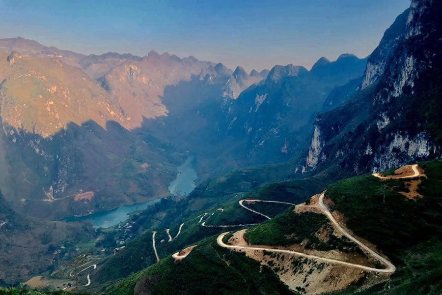
The Ta Lang descent road involves genuinely steep slopes and sharp switchback turns down to Trang Huong bridge, difficult enough that most riders park higher up and hire a local shuttle for the final stretch rather than riding a fully loaded bike all the way down.
The road itself is not long, but the combination of grade, tight turns, and loose surface in places makes it a meaningfully different proposition from the rest of the loop, and riders are advised to inspect their bike and their own confidence honestly before attempting it (Source: Origin Vietnam). Parking near Trang Huong bridge and either walking down or hiring a local xe om (motorbike taxi) or shuttle for the final descent removes the risk entirely.
The shuttle typically costs only a small amount per person, a trade most riders find easily worth it after seeing the road for themselves. The Xin Cai side asks less of the motorbike itself since more of the final approach is on foot, roughly 2 kilometers after the road ends, which trades a longer walk for meaningfully less two-wheeled risk overall.
Vani Tip: if you have any doubt at all about the Ta Lang switchbacks, take the shuttle. I would rather a guest spend an extra small amount of cash and ten minutes waiting than attempt a descent that has caught out riders far more experienced than a typical first-time loop guest, especially with a loaded pannier changing how the bike handles. 🏍️
Why Does the Nho Que River Turn This Exact Shade of Turquoise?
The turquoise color comes from fine limestone particles suspended in the water, a well-documented optical effect in karst rivers generally, not unique to the Nho Que River in Ha Giang province but especially visible here because of how much limestone the water passes through on its way down from the plateau. 💧

As river water moves through limestone terrain, it breaks tiny fragments of calcium carbonate loose and carries them along suspended in the current. When sunlight strikes those fine mineral particles, it scatters in a way that produces the distinctive blue-green color travelers associate with karst rivers worldwide (Source: National Park Service). The clearer the water and the higher that mineral load relative to organic sediment, the more saturated the turquoise reads. This is part of why color varies noticeably by season; heavier monsoon flow between June and October carries more churned sediment and less of the fine suspended limestone that produces the cleanest color. Meanwhile, the cooler, drier months after the rains settle into exactly the conditions that produce the water color the river is known for.
When Is the Best Time to See the Nho Que River Turquoise Water?
September through November gives a reliable combination of clear turquoise water and blooming buckwheat flowers on the surrounding plateau, with November generally rated as a highly recommended month for both. 🌸
That window sits right after the summer monsoon has tapered off, so sediment has largely settled while the karst springs still keep the river flowing well, producing the cleanest color of the year. It overlaps directly with the buckwheat flower season across Dong Van and Meo Vac, which our Dong Van Karst Plateau Geopark guide covers in full, including exactly which villages hold the densest blooms. Outside that window, the broader dry season running into early spring still tends to give clearer water than the summer months, but without the added color of the buckwheat fields lining the roads and terraces above the canyon.
Looking For The Best Vietnam Holiday Packages?
Discover top-rated tours designed by experts. Let’s make your journey across Vietnam truly extraordinary.
Frequently Asked Questions About the Nho Que River
How much does the Nho Que River boat cost?
Quick Answer: Roughly 100,000 to 150,000 VND per person for a standard motorboat or self-rowing boat, or from around 50,000 VND for a kayak, confirmed at the pier since prices can shift by season and operator.
Which pier should I use, Ta Lang or Xin Cai?
Quick Answer: Use Ta Lang if you are staying in Dong Van, and Xin Cai if you are staying in Meo Vac. Both reach the same stretch of Tu San Canyon, so the choice is about which town you are based in that night, not which view is better.
How far is the Nho Que River from Hanoi?
Quick Answer: Roughly 410 to 430 kilometers door to door, a 300-kilometer bus or drive to Ha Giang city followed by another 110 to 130 kilometers of mountain road on to Meo Vac.
Is the road down to the Nho Que River boat piers dangerous?
Quick Answer: The Ta Lang descent has steep slopes and sharp switchback turns, difficult enough that most riders park near Trang Huong bridge and hire a local shuttle for the final stretch rather than riding a loaded bike all the way down. The Xin Cai side involves more walking and less motorbike risk.
When is the best time to see the turquoise water?
Quick Answer: September through November, with November generally being a strong choice, since sediment has settled after the summer monsoon and the window overlaps with peak buckwheat bloom on the surrounding plateau.
How long does the Nho Que River boat ride take?
Quick Answer: Roughly 60 to 90 minutes round trip, moving at an unhurried pace with a pause at the narrowest point of Tu San Canyon for photos.
Conclusion
The Nho Que River boat ride earns its reputation as a visual highlight of the Ha Giang Loop, and it stops being a source of last-minute stress once you know the three things that actually matter: which pier matches where you are sleeping, what the ticket costs, and how much the descent road asks of you and your bike. ✨
Choose Ta Lang from Dong Van or Xin Cai from Meo Vac, budget 100,000 to 150,000 VND and roughly 1.5 to 2 hours door to door. Truly Voyage’s pre-booked river excursions are timed directly into our wider loop itineraries, so this stop is something planned in advance rather than improvised at the water’s edge.
Start Planning Your Trip Now
Let’s turn your travel dreams into reality with our expert guides and well-planned routes.
Further Reading & Resources
- VietnamPlus — Tu San Canyon depth, length, and cliff slope figures. Direct Link
- Vietnam Coracle — boat ride duration and a real-world pricing example. Direct Link
- Vinpearl — Ta Lang Wharf location and distance from Dong Van. Direct Link
- Origin Vietnam — Ta Lang descent road difficulty and access notes. Direct Link
- Local Vietnam — cash-only pier payment practices. Direct Link
- National Park Service — the limestone science behind karst river water color. Direct Link

Vani is the Founder and Lead Travel Designer at Truly Voyage. With over a decade of experience and a deep passion for her Vietnamese heritage, she specializes in crafting bespoke, unhurried itineraries. Vani is dedicated to helping travellers experience the authentic soul of Southeast Asia with absolute financial security and 24/7 on-ground support.
0 Comment