

 By Vani
Pha Luong Peak is a demanding day trek near Moc Chau, with forest trails and an exposed summit viewpoint. Before planning the climb, confirm current access for your nationality, paperwork and the permitted starting time. Allow for the approach drive as well as the hike, and choose a different day or activity if conditions do not suit you.

Pha Luong Peak calls for two separate decisions: whether access can be arranged for your travel date and whether the walking suits your group. The approach is roughly 40 kilometres from Moc Chau, so clarify access before committing a day of your itinerary. Truly Voyage can discuss how this trek might fit your wider journey.
This guide brings together the access questions, an illustrative early-start schedule, trekking comparisons and packing considerations. The timings are planning estimates rather than an approved route schedule. Confirm the arrangements for your date before booking transport or assuming the summit will be accessible.
What Is the Pha Luong Peak Hike, and Where Does It Sit?
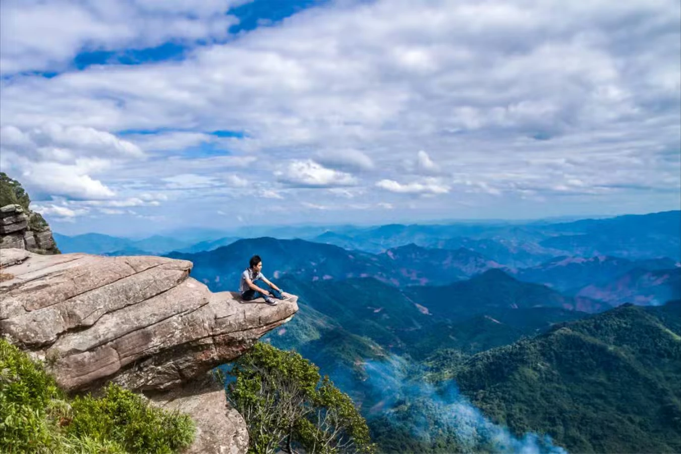
Pha Luong Peak stands close to 2,000 metres above sea level directly on the Vietnam and Laos border, roughly 40 kilometres from Moc Chau town, and it is known locally as the roof of Moc Chau for its overhanging cliff edge above a sea of cloud. ☁️
Pha Luong Peak’s Altitude, Border Location and Poetic History
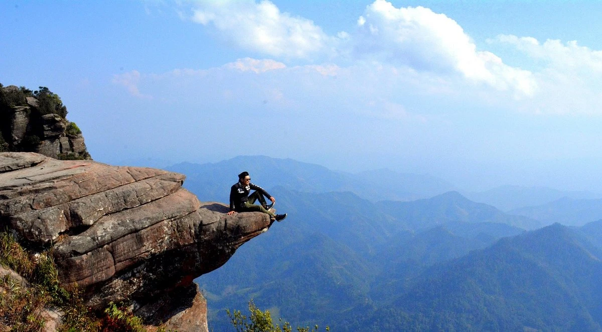
The summit is described as almost 2,000 metres high, some 40 kilometres from Moc Chau town, near the Vietnam–Laos border. Known as the roof of Moc Chau, Pha Luong offers views over forests and villages, with an exposed rock shelf near the top that has become a widely photographed ledge in Son La province. The viewpoint is a draw for mountain walkers, but a photograph does not show the effort of reaching it or the conditions on the day.
Pha Luong also has a literary association: it is named in Tay Tien, the 1948 poem by Quang Dung about a Vietnamese army regiment in the Northwest during the resistance war against France. That cultural context offers another way to understand the mountain beyond its summit photographs.
What Permit Do Pha Luong Peak Foreign Trekkers Need?
Ask whether Pha Luong is currently open to your nationality and which authority can confirm access. Do not assume that a guide booking, a passport or an application means permission has been granted.
Questions to Resolve Before Arranging a Pha Luong Trek
Resolve access before arranging the approach drive. Ask your local contact to check the current position with the responsible border authority, including any distinction between Vietnamese and foreign passport holders. Request the issuing authority, documents needed, processing time and conditions for your intended route and date.
Allow advance planning time rather than relying on a same-day answer. Before sharing passport details, establish who needs them and how they will be submitted. Ask what written confirmation you should carry, whether you need your original passport, and what happens to transport or guide charges if access is refused. A guide can help you ask these questions; hiring one is not permission to enter.

Does Pha Luong Peak Suit Your Group?
Treat access and walking ability as separate checks. Even with confirmed access, the exposed sections may not suit everyone travelling together.
Before you go
- Access: Confirm eligibility, paperwork and the latest permitted starting time before committing to the drive.
- Walking: Discuss the steep descent and exposed rock with your guide, as well as your preferred pace and rest stops.
- Flexibility: Agree a turnaround time and an alternative plan if weather or access prevents the climb.
Who it suits: Walkers comfortable with a sustained ascent, a steep descent and exposed sections, with access confirmed for their date.
Who may prefer something else: Travellers seeking a gentle outing or uncomfortable with heights can use the Moc Chau Plateau guide to consider a different day.
Start the access conversation before booking your transport. Ask for confirmation that applies to your passport, route and travel date.

A JOURNEY SHAPED AROUND YOU
Your Vietnam journey.
At your own pace.
Tell us what you enjoy, how you like to travel and where you would like more time. We can discuss a private itinerary around your interests and preferred pace.
When Should You Reach the Station for the Pha Luong Peak Trek?
Plan an early start, but ask the responsible authority to confirm the latest permitted arrival and starting times. Leave room for the approach, document checks, rest stops and the return descent.
A Sample One-Day Pha Luong Peak Trekking Itinerary from Moc Chau
The approach includes a rougher final section that can slow the journey. Build in a buffer rather than scheduling the start from the map distance alone. The table is an illustrative early-start plan to discuss with a guide, not a timetable to follow regardless of conditions. Its return time depends on your walking pace and stops; allow longer if your descent takes the full two hours estimated below.
| Time | Activity |
|---|---|
| 05:30 | Depart Moc Chau town |
| 07:00 to 07:30 | Arrive at the station for agreed access checks |
| 07:30 to 08:00 | Begin the ascent |
| 11:00 to 12:00 | Reach the summit, rest and photograph |
| 12:00 to 13:30 | Descend |
| 14:00 | Aim to return to the station; allow longer if needed |

The sample plan leaves Moc Chau at 05:30. Adjust departure to the confirmed access window, the approach conditions and your group’s walking pace.
How Hard Is the Pha Luong Peak Trekking Climb, Honestly?
Allow roughly 3 to 4 hours climbing and 1.5 to 2 hours descending as initial planning estimates. Narrow trails and exposed sections make this a sustained walk, even though it can fit into a day. Your guide should adjust those estimates to your group and conditions.
Ascent, Descent and How Pha Luong Compares to Fansipan and Ta Xua
The climb passes through forest trail, narrow sections threaded with vines, and stretches of stacked rock and exposed ledges rather than consistently open ground. Discuss footwear and trekking poles with your guide, and allow time for the descent instead of treating it as a quick return. The 1.5 to 2 hour descent estimate is a starting point for planning, not a pace every walker should aim to match.
Placed against two treks many visitors already know, Pha Luong sits closer to an ambitious single day hike than a mountaineering expedition. Is the Pha Luong Peak hike difficult for beginners? It is achievable for a reasonably fit beginner with a guide and good weather, but it is not a casual stroll, and the exposed sections near the summit are where the real difficulty concentrates rather than the distance covered.

| Trek | Elevation | Typical Duration | Access | Difficulty Note |
|---|---|---|---|---|
| Pha Luong Peak | Close to 2,000m | Single day, roughly 3 to 4 hours up, 1.5 to 2 hours down | Confirm current access | Steep and exposed near the summit, but realistic as a single day trek |
| Ta Xua Peak | 2,865m | 2 to 4 days, several hours of trekking daily | Confirm route and overnight plan | Narrow ridgeline sections; route matters |
| Fansipan | 3,143m | 1 to 3 days trekking, or around 15 minutes by cable car | Confirm park access or cable-car arrangements | Trekking and a cable-car visit are different outings |
Consider trekking poles alongside sturdy footwear. Discuss the descent with your guide before committing to the ascent, especially if steep downhill walking is uncomfortable for you.
When Is the Best Season for the Pha Luong Peak Hike?
December to April is the suggested planning window in this guide, with January and February worth discussing if cloud views are your priority. Treat these months as a starting point: the actual forecast, trail conditions and access decision matter more than a seasonal label.
December to April, and the Pha Luong Peak Sea of Clouds Best Time to Visit

Keep the weather decision separate from the month you book. If you are considering September or October, discuss the forecast and trail conditions rather than assuming the climb will go ahead. A flexible spare day can help you change plans. The sea of clouds is the layer of cloud seen below the summit; it may obscure a valley or be absent on your visit. Choose the trek for the walk as well as the photograph, and ask your guide what conditions would lead to postponement.
If cloud views are your priority, discuss January or February as possible dates, while keeping another activity in reserve if the forecast or access does not suit the trek.
Why Is a Local Guide Pha Luong Peak Trek Essential, and What Should You Pack?
Ask for a guide familiar with this specific route, then confirm what their service includes. Route knowledge, access enquiries and porter support are separate arrangements; do not assume that one booking covers them all.
Packing List and Why an Experienced Local Guide Is Worth It
Prepare for the full walking day, including the descent. Discuss layered clothing, a headlamp, water, high-energy snacks, trekking poles and a rain shell with your guide. A planning allowance of 1.5 litres of water should not be treated as sufficient for everyone: agree what to carry for your pace and the conditions, rather than relying on the forecast for Moc Chau town alone.
If carrying water and equipment would make the climb harder for you, ask whether porter support is available and what it costs. Confirm the load, meeting point and responsibilities rather than assuming a porter is included with a guide. Ask when the guide last worked the route, how they will confirm current access, and how they would adjust the day for your walking pace. Personal familiarity with staff is not a substitute for the required approval.
What Safety Rules Matter Most on the Pha Luong Peak Trek?
Discuss the exposed summit area with your guide before starting. Agree when you will turn back and which conditions would cancel the climb; reaching the viewpoint should not override that plan.
Exposure, Wet Rock and Setting a Turnaround Time

Consider whether you are comfortable with the exposed rock shelf before making it the goal of your trip. Ask the guide where you can pause or turn back, and avoid planning a photograph that depends on standing at the edge. Discuss how rain would change the approach and the walking route, with postponement as an option rather than a failed day.
A turnaround time is the hour you agree to begin descending, even if you have not reached the summit. Set it with your guide before walking, allowing for your pace, rest stops and the return journey. It is a planning tool, not a promise that the route will remain suitable until that hour.
Set your turnaround time out loud with your guide before you start walking. Turn back earlier if conditions or your comfort call for it.
What Else Should You Read Before Your Pha Luong Day?
This guide focuses on the trek itself, from access planning to descent. Use the related guides for the wider plateau, the seasonal calendar and the journey from Hanoi.
Where the Rest of the Moc Chau Picture Lives
For general orientation to the wider plateau, including the other three zones and how Pha Luong fits into a three or four day itinerary, our Moc Chau Plateau guide covers the full map. If you have not yet worked out how to reach Moc Chau town in the first place, our transport guide covers the wider journey from Hanoi, and our seasonal guide sets out the plateau’s full month-by-month calendar alongside this trek’s own December to April window.
| If You Are Looking For | Read This Next |
|---|---|
| The plateau’s full four-zone layout and how Pha Luong fits in | Moc Chau Plateau: The Complete Guide |
| Bus, limousine, car and motorbike fares from Hanoi | How to Get to Moc Chau from Hanoi |
| The month-by-month flower and weather calendar | When to Visit Moc Chau Vietnam |
Frequently Asked Questions
Can foreigners climb Pha Luong Peak?
Confirm current eligibility for your nationality and travel date with the responsible border authority before booking the approach drive. Do not assume access is available or that a guide booking establishes permission.
Do you need a permit for Pha Luong Peak?
Ask which documents and approvals apply to your passport, route and date, who issues them, and what confirmation you should carry. Resolve these questions in advance rather than relying on a same-day arrangement.
Is the Pha Luong Peak hike difficult for beginners?
It is achievable for a reasonably fit beginner trekking with a guide in good weather, with most of the real difficulty concentrated in the exposed, narrow sections near the summit rather than the overall distance.
How long does the Pha Luong Peak trek take?
Use roughly 3 to 4 hours to ascend and 1.5 to 2 hours to descend as planning estimates, in addition to the approach drive and access checks. Ask your guide to adjust the schedule to your group and conditions.
What is the best month for the sea of clouds at Pha Luong?
January and February are suggested dates to discuss within the December to April planning window. Cloud views cannot be promised; make the decision using the forecast, route conditions and confirmed access for your date.
Conclusion
Pha Luong Peak is a day-trek option for walkers who are comfortable with sustained climbing and exposed terrain. Confirm access first, then discuss the approach, walking pace and turnaround time. Keep an alternative in your Moc Chau plans if the climb does not suit your group or the conditions on the day.
The estimated 3 to 4 hour ascent is one part of the day; the descent, drive and access arrangements also need time. Discuss your plans with Truly Voyage before making the summit the fixed centrepiece of your itinerary.
Further Reading & Resources
Related guides
A JOURNEY SHAPED AROUND YOU
Your Vietnam journey.
At your own pace.
Tell us what you enjoy, how you like to travel and where you would like more time. We can discuss a private itinerary around your interests and preferred pace.

Vani is the Founder and Lead Travel Designer at Truly Voyage. With over a decade of experience and a deep passion for her Vietnamese heritage, she specializes in crafting bespoke, unhurried itineraries. Vani is dedicated to helping travellers experience the authentic soul of Southeast Asia with absolute financial security and 24/7 on-ground support.
0 Comment