


Planning to ride the Hai Van Pass? This roughly 21-kilometre coastal route connects Hue and Da Nang, offering stunning ocean views. If you are worried about tight hairpins or sudden fog, our comprehensive guide covers safety tips, historical viewpoints, and estimated travel times to ensure an unforgettable, secure journey.
Round the third hairpin bend and the mist simply swallows the road ahead of you. 🌫️ This is what gives the Hai Van Pass its name, Ocean Cloud Pass, and for a few disorienting seconds you cannot see the drop to your right or the climb to your left, only white. Then the cloud breaks, and Da Nang Bay opens up hundreds of metres below, a sweep of blue and green that a British television presenter once called one of the best coast roads in the world. I am Vani, founder of Truly Voyage, and this guide gives you the pass as it actually is today: its history, its best stops, and an honest answer to the question every rider eventually asks, which is whether it is actually safe to cross.

Table of Contents
ToggleWhat Is the Hai Van Pass?
The Hai Van Pass is a roughly 20 to 21 kilometre mountain road on National Route 1, connecting Hue and Da Nang, climbing to a summit of around 480 to 500 metres above sea level. ⛰️
Its Vietnamese name, Deo Hai Van, translates to Ocean Cloud Pass, a description that earns itself the moment you cross the ridge and the sea mist that regularly rises from the coast wraps around the summit, cutting visibility to almost nothing before clearing again just as suddenly (Source: Hải Vân Pass, Wikipedia). The road climbs the Bach Ma range, a spur of the wider Annamite mountains that pushes straight into the South China Sea, and it functions as a genuine climatic divide as much as a geographic one: Hue’s side of the pass tends to run cooler and wetter for much of the year 🌧️, while Da Nang’s side warms up noticeably once you descend, a shift you can often feel within a single hairpin bend rather than gradually over the whole climb.

From central Da Nang, the base of the ascent sits around 20 kilometres away, roughly a 30 to 45 minute drive before the climbing even starts; from Hue, the equivalent distance runs closer to 70 to 80 kilometres. Most riders and drivers cross the pass as one leg of a longer Hue-to-Da Nang or Da Nang-to-Hoi An route rather than a standalone destination, since the surrounding towns, Lang Co to the north and central Da Nang to the south, both sit within easy reach of either end.
What Is the Historical Significance of the Pass?
For nearly two centuries, the Hai Van Pass was a literal international border, and for a century after that it was one of imperial Vietnam’s most heavily defended military positions. ⚔️
The pass marked the frontier between the kingdom of Champa and the Vietnamese kingdom of Dai Viet from 1306, following a royal marriage that ceded the surrounding land as a dowry, until Dai Viet’s conquest of Champa’s remaining northern territory in 1471 (Source: Hải Vân Pass, Wikipedia). Centuries later, in 1826, Emperor Minh Mang ordered the fortified gate at the summit, Hai Van Quan, substantially rebuilt to guard the route to his imperial capital, a position so strategically important to Hue’s defence that locals of the period reportedly referred to it as the throat of the capital. He inscribed the Hue-facing side with the gate’s own name and the Da Nang-facing side with a phrase that translates roughly to the world’s most magnificent gateway.

The gate has been fought over since: French colonial forces and, later, American and South Vietnamese troops during the Vietnam War added bunkers and gun positions to the same high ground, ruins of which remain visible near the summit today (Source: Danang Fantasticity). Nearly two centuries of weather and warfare eventually left the fort badly deteriorated, until a joint restoration by Thua Thien Hue and Da Nang authorities, begun in late 2021 with a budget of roughly VND 42 billion, returned it to public view on 1 August 2024, drawing more than 1,200 visitors on its opening day alone.
The pass gained an entirely different kind of fame in December 2008, when the BBC’s Top Gear featured it during their Vietnam special. Jeremy Clarkson’s verdict, that it was a deserted ribbon of perfection, one of the best coast roads in the world, has followed the pass ever since, and a fair share of the motorbike tours now running the route still trade on the association. 🏍️
Vani Tips: stop at Hai Van Quan itself, not just a roadside viewpoint. 💡 The restored fort adds real historical context the drive-by views do not, and understanding what the inscriptions and bunkers actually represent changes how the rest of the ride reads.
What Are the Top Viewpoints and Photo Stops on the Hai Van Pass?
Three stops cover most of what makes the pass worth photographing, and each one shows you something the other two do not. 📸
At the summit, the restored Hai Van Quan fort combines old military ruins with genuinely sweeping views in both directions: south over Da Nang Bay and the Son Tra Peninsula, north over Lang Co’s curving lagoon and beach, the whole panorama shifting from clear blue to grey mist and back again depending on which way the wind is pushing the cloud that day.
A short distance below, on the Lang Co side, sits the spot informally known among riders as the Top Gear viewpoint, the same stretch of coastline the show’s presenters singled out during their 2008 episode, and it remains one of the most reliably photogenic pull-offs on the entire route, framing the lagoon, the beach, and the mountains behind it in a single unbroken sweep.
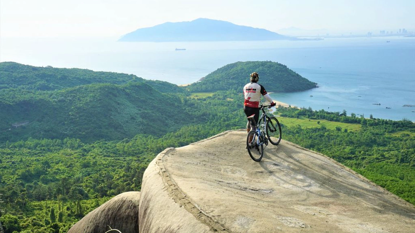
Closer to the Da Nang side of the climb, a natural rock outcrop known as Turtle Rock offers a third, distinct angle over Da Nang Bay and the peninsula, popular enough with both riders and cyclists that a small coffee stall has set up beside it, a genuinely good excuse to pause with a hot drink ☕ and let the view sit for a while rather than snapping a photo and moving straight on.
Vani Tips: photograph both directions from the summit. The Da Nang side and the Lang Co side look genuinely different, one opening onto a city skyline and a peninsula, the other onto a quiet curve of lagoon and beach, and both are worth the stop rather than settling for whichever view happens to face your direction of travel.
Ready to conquer the Hai Van Pass?
Join our carefully curated local tours and experience Vietnam’s most breathtaking coastal roads safely with expert guides.
Case Study: A Step-by-Step Hai Van Pass Motorbike Experience
To give you a clearer picture of what riding this route entails, here is a real step-by-step experience from our guests, David and Emma, who rode from Hue to Da Nang in May. 🛵
- Morning Departure (8:00 AM): They left Hue early to avoid the midday heat. The 70-kilometre flat ride along the highway to Lang Co was smooth and straightforward.
- Coffee at Lang Co Lagoon (9:30 AM): A quick stop for traditional Vietnamese iced coffee to stretch their legs before the real ascent began.
- The Climb & The Fog (10:15 AM): Navigating the hairpins, they encountered a sudden patch of mist near the top. By maintaining a slow, steady speed and using the horn around blind corners—just like the locals do—they safely navigated the low-visibility stretch.
- Summit Exploration (10:45 AM): They spent 45 minutes exploring the newly restored Hai Van Quan fort, capturing panoramic shots of the historical bunkers and the sweeping bays below.
- Descent into Da Nang (11:30 AM): The southern descent was sunny and clear. A quick stop at Turtle Rock provided the perfect final photo opportunity before arriving safely in the city.

| Feature | Open Pass Road | Hai Van Tunnel |
|---|---|---|
| Travel Time | 45–60 minutes | ~15 minutes |
| Scenery | Panoramic ocean and mountain views | Enclosed concrete tunnel |
| Allowed Vehicles | Motorbikes, cars, bicycles | Cars, buses, trucks (No motorbikes) |
| Best For | Adventure, photography, history | Speed, rainy days, pure transit |
Is the Hai Van Pass Dangerous?
The honest answer sits between the two extremes most people expect: the road carries real risk factors worth taking seriously, but it is genuinely quieter and safer than its old reputation suggests.
Tight hairpin bends, sea fog that can drop visibility to almost nothing within seconds, wet surfaces during the rainy season, and occasional oil residue from trucks are all real, current risk factors on the open pass road. ⚠️ We could not find comprehensive published accident statistics for the pass road itself, and that absence should be read as a genuine information gap rather than proof of either a high or low risk.

What is well documented is what has changed since the road’s most dangerous years: the Hai Van Tunnel, opened in June 2005, now carries the vast majority of through-traffic, buses, trucks, and most cars, off the open pass entirely. The tunnel operator’s own 20-year operational data, published in 2025, credits its rescue team with handling 156 traffic accidents across almost 48 million vehicle transits over two decades (Source: 20 Years of Hai Van Tunnel – A Timeless Milestone, HHV / Deo Ca Group), a strong indicator that shifting heavy traffic underground has made the open route considerably quieter than its pre-tunnel years, when accidents on the pass road were reportedly a near-daily occurrence.
Vani Tips: avoid the pass in poor weather if you have flexibility in your schedule. Fog is the single biggest factor that turns a scenic drive into a genuinely tense one, since it can close down visibility on a hairpin bend with almost no warning.
Vani Tips: take the tunnel instead of the pass if you are driving a car with no particular interest in the scenery. 🚗 It is faster, and per the operator’s own safety data, it is well used by through-traffic for good reason.
Beyond the tunnel itself, a handful of practical habits do more for your safety on the open road than any single piece of equipment: keep a moderate, predictable speed through the hairpins rather than chasing a personal best, use your horn on blind bends the way local traffic does, and give any truck or bus a wide margin, since they are often the vehicles least able to adjust quickly if fog rolls in mid-turn.
When Is the Best Time to Visit the Hai Van Pass?
The clearest riding window runs roughly March to September, with April through July offering the most reliable visibility for the summit views the pass is actually known for. ☀️
Outside that window, the northeast monsoon brings cloud, fog, and slippery conditions that can obscure the summit view entirely and turn the hairpin sections genuinely more demanding than they are in dry weather. Early morning departures tend to beat both the worst of the day’s heat and the coach parties that arrive in a concentrated wave through late morning and early afternoon, and mist tends to burn off faster on the Da Nang side of the ridge than it does on Hue’s, so a clear photo at the summit is not always a guarantee even once you have picked a good month. Checking a same-day forecast before you commit to riding the open road, rather than the tunnel, is worth the extra few minutes it takes.

Vani Tips: ride the pass itself only if you are already comfortable on a motorbike. If you would rather experience the views without riding solo, our dedicated Hai Van Pass Loop guide covers guided pillion options and Easy Rider tours that put an experienced local driver in control while you take in the scenery.
Seeking more epic roads and cultural discoveries?
Our dedicated team is ready to design your ideal Vietnam holiday. Get in touch today for personalized recommendations.
Frequently Asked Questions About the Hai Van Pass
Is the Hai Van Pass safe to ride?
Quick Answer: It carries real risk factors, hairpins, fog, and wet roads, but most heavy traffic now uses the Hai Van Tunnel instead, leaving the open pass quieter than in past decades.
How long does the Hai Van Pass take?
Quick Answer: About 45 to 60 minutes by motorbike or around 30 minutes by car for the pass road itself, not counting stops, though most visitors build in two to three hours for photos and the summit fort. ⏱️
Why is it called the Hai Van Pass?
Quick Answer: Hai Van translates to Ocean Cloud, describing the sea mist that regularly rises to the summit and can cut visibility with little warning.
How long is the Hai Van Pass?
Quick Answer: Roughly 20 to 21 kilometres along National Route 1, climbing to a summit of around 480 to 500 metres above sea level.
Is the Hai Van Pass worth doing if I am not on a motorbike?
Quick Answer: Yes. The road is fully paved and suitable for cars, taxis, and buses, and the summit views and Hai Van Quan fort are just as accessible without a motorbike.
Can you cycle the Hai Van Pass?
Quick Answer: Yes, and it is a genuinely popular route for road cyclists 🚴, though the climb is demanding enough that most riders treat it as a dedicated half-day effort rather than a casual add-on.
Conclusion
The Hai Van Pass deserves to be judged on what it actually is today, not on a decades-old reputation or a single famous quote from a car show.
That means taking its real risk factors seriously, fog above all, while also recognising that the tunnel has quietly done more to change the safety picture here than almost anything else in the pass’s long history. Cross it on a clear day, stop properly at Hai Van Quan rather than just slowing down for a photo, and you get both the scenery that earned the pass its fame and the historical weight that most quick drive-throughs miss entirely. Truly Voyage builds the Hai Van Pass into Hue and Da Nang itineraries with that full picture in mind, and our dedicated Hai Van Pass Loop guide covers the motorbike and Easy Rider side of things in full if riding it yourself is part of your plan.
Let’s make your Vietnam journey unforgettable!
From the historic imperial capital to sweeping mountain passes, we handle the details so you can enjoy the ride.
Further Reading & Resources
- Hải Vân Pass, Wikipedia — length, elevation, and the 1306 to 1471 Champa–Dai Viet border history. Direct Link
- Hai Van Pass, Danang Fantasticity, Da Nang City Tourism Information Portal — Hai Van Quan’s inscriptions and the pass’s viewpoints. Direct Link
- Hai Van Gate: A Heavenly Gateway Through the Clouds, VinWonders — the 2021 to 2024 restoration timeline and cost. Direct Link
- Hai Van Gate Reopens with a New Facelift, The Saigon Times — the August 2024 reopening and visitor numbers. Direct Link
- Top Gear: Vietnam Special, Wikipedia — broadcast date and details of the December 2008 episode. Direct Link
- 20 Years of Hai Van Tunnel – A Timeless Milestone, HHV / Deo Ca Group — the tunnel’s 20-year accident and vehicle-transit data. Direct Link
- Turtle Rock, Hai Van Pass, Hoi An Day Trip — Turtle Rock’s location and views on the Da Nang side of the climb. Direct Link

Vani is the Founder and Lead Travel Designer at Truly Voyage. With over a decade of experience and a deep passion for her Vietnamese heritage, she specializes in crafting bespoke, unhurried itineraries. Vani is dedicated to helping travellers experience the authentic soul of Southeast Asia with absolute financial security and 24/7 on-ground support.
0 Comment